
 |
 |
 |
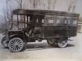
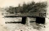
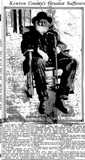
| The Erlanger - Fort Mitchell Bus | Beechwood Road Bridges | |
 |
 |
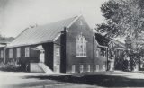
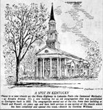
| Fort Mitchell Baptist Church, 1956 |
St. Agnes, Ft. Wright, c. 1930 |
![]()
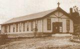
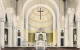
Blessed Sacrament, 1920
| The image is from this story on the cornerstone laying of the new building. This building originally served as both church and school. The red brick was replaced with buff brick in the 1950's to match the new church. |
 |
 |
 |
 |
| 1956 | 1959 | ||
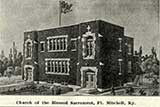
Church of the Blessed Sacrament, South Fort Mitchell. Blessed Sacrament's web site is here. |
|||
The Rev. Paul Ryan's 1953 history of Blessed Sacrament is here.
![]()
 |
 |
 |
|
| From a Facebook post by D. Russell | |||
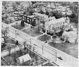
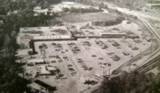
| Aerial views from the 1960's | 1976 | ||
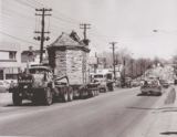 |
| How did the Monte Casino
Chapel get from Covington to Thomas More? On a truck, thru Fort Mitchell. May 7, 1965. Details here. Bob Huesman is the man on top of the church. |
1903
 |
 |
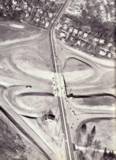
| Looking north, at Dixie and Beechwood Road. |
Looking south at roughly Dixie and Rivard. |
Both from the Gilliam Collection, Eva G. Farris Special Collections, W. Frank Steely Library, Northern Kentucky University.
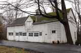
Video of the Roger Kuchle Garage shortly before it was torn down.
Fort Mitchell pioneer Pope Sandford
Kentucky Post, December 1, 1916
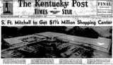
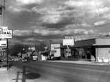
New Shopping Center coming. The full story.
 |
 |
|
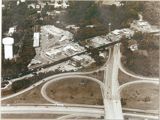
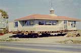
| Howard Johnson's, on its was south to the new Expressway Plaza, where it would become Robertson's. right, Kentucky Post, September 1, 1958 | ||
 |
 |
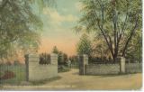
| Entrance to Highland Cemetery, 1912 |
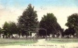
Entrance to St. Mary |
| Fort Mitchell's first cemetery was St. Johns, which opened in 1867. Highland opened in 1869, and St. Mary's in 1870. St Mary's had an an earlier location in Devou Park. Why two Catholic cemetery's? One for the German Catholic (St. John's) and one for the Irish Catholic (St. Mary's). | |
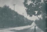
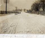
The caption on this one says “Scene on US 25/42 near Covington”
We think it's looking north, with Turkeyfoot Road on the left.
Thanks to Lt. Barry Martin and Tyler Schmidt for help in identifying the location
 |
 |
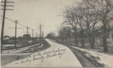
| We believe this is the same scene as above. Sorry for the picture quality. |
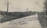
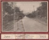
We believe this, too, is the same scene. 1916 |
Lakeside Presbyterian Church
Venthaven
Visit Venthaven on-line here.
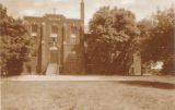
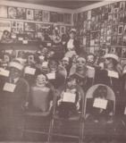
St. John's Orphanage
On Orphanage Road, originally organized in 1850 in Covington.
At the time of this picture, c. 1950, there were 118 boys and girls, from 2-18 years
old under the supervision of a Chaplain and 12 Nuns
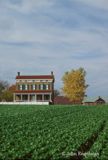
The Kruempelman Farm, c. 1975
from a Facebook post by the photographer, John Engleman
![]()
| These seven properties, more or less in Fort Mitchell, are on the National Register of Historic Places. Each has a history, maps, sources, and maps. | |||
| Beechwood Historic District | Highland Cemetery District | Kruempelman Farmhouse | Shinkle-Brinks House |
| Fort Mitchell Heights | Fort Mitchell | Old Fort Mitchell | Lakeside Park |
![]()
| Union General Lew Wallace, in charge of defending Cincinnati in the Civil War, used this barn in Fort Mitchell to store his horses. From a Facebook post by Dr. Richard Cardosi |
Fort Mitchell, c. 1960's|
From a Facebook post by Will Terwort
 |
 |
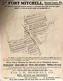
| Fort Mitchell lots for sale. Note the trolley line. We're not sure of the date on this one. From a Facebook post by Joe Schulte | “Most healthful place within 50 miles of Cincinnati.” Kentucky Post, September 17, 1904 |
| Our assumption is that the ad on the right refers to the plat on the left. We can tell you that in June of 1911, Simrall was advertising “very few lots left.” | |
We're told Sanford Street, on the plat above, was renamed Iris because of the number of flowers planted along the street by Mrs. Philip Queal. Her husband was a Fort Mitchell City Clerk for 50 years. |
| The City of Fort Mitchell was incorporated on Valentine's Day in 1910 | Long-time Fort Mitchell area resident August Hauer remembered the Civil War; his 1943 interview - he was 84 - is here. |
| “A new civic group will spearhead the battle of Ft. Mitchell's citizens against the proposed Greater Cincinnati Airport Highway. Property owners contend that the express highway would reduce property values and cut the community in half. According to reports at the meeting, about 13 persons would be “punished” by having the high way cut across or cut through their property.” Cincinnati Enquirer, April 5, 1949 | |
| You can read Mr. John R. Blakely's The Early History and Development of Ft. Mitchell, a paper presented top the Gist Historical Society, here. (pdf) | Park Hills incorporated as a real city on June 28, 1927. A history of Park Hills is on the city's web site. |
| You can read Mrs. Richard Udry's history of Fort Mitchell, South Fort Mitchell and Lakeside Park, from 1940, here. | Mrs. Udry's History of Fort Mitchell. |
| Fort Mitchell booming, 1910. | Fort Mitchell's phenomenal growth, 1910. |
| Fort Mitchell looks to expand city limits, 1927 | Fort Mitchell and South Fort Mitchell merge, in 1966. |
| The Official Ft. Mitchell Page is here. | Fort Mitchell auto registrations from 1910 are here. |
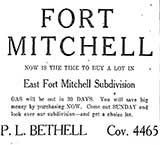
East Fort Mitchell?
Kentucky Post, October 29, 1927
![]()